

New Orleans Faces Critical Infrastructure Challenge as Land Subsides at Alarming Rates
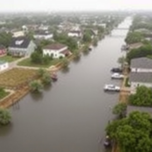
New Orleans, a city revered for its rich cultural heritage and vibrant landscapes, is undergoing a slow yet palpable transformation that threatens its very foundation. A recent investigation led by Tulane University researchers has unveiled concerning revelations: sections of the city and its surrounding wetlands are sinking at an increasing rate. This phenomenon poses significant risks to the effectiveness of the city’s $15 billion flood protection system, painstakingly constructed after the devastation wrought by Hurricane Katrina.
The research presented in the journal Science Advances utilized sophisticated satellite radar technology to observe minute shifts in land elevation across the Greater New Orleans area from 2002 to 2020. Through the use of Interferometric Synthetic Aperture Radar (InSAR), scientists have detected alarming rates of subsidence — some neighborhoods and wetlands experiencing declines exceeding one inch per year, with select locales reporting almost two inches of elevation loss annually. Such drastic changes raise pivotal concerns about heightened flood risk in a city where even minimal adjustments in elevation can have catastrophic consequences.
.adsslot_BxsOlYRDMq{ width:728px !important; height:90px !important; }
@media (max-width:1199px) { .adsslot_BxsOlYRDMq{ width:468px !important; height:60px !important; } }
@media (max-width:767px) { .adsslot_BxsOlYRDMq{ width:320px !important; height:50px !important; } }
ADVERTISEMENT
The implications of these findings extend beyond mere statistics; they underscore the nuanced interplay of natural and anthropogenic factors contributing to land subsidence. The researchers identified a myriad of causes ranging from natural soil compaction processes to human activities like groundwater extraction, industrial encroachment, and the long-standing practice of wetland drainage for urban expansion. Each of these elements interactively contributes to the complex dynamics reshaping the landscape of New Orleans, dramatically increasing vulnerability to potential flooding events.
Among the findings that emerge from this critical study is the unsettling revelation that even the infrastructure designed to protect New Orleans is not immune to sinking. Data indicates that concrete floodwalls and levees, integral components of the Hurricane and Storm Damage Risk Reduction System (HSDRRS), are themselves failing to maintain their intended elevation. In fact, in a few instances, flood protection structures are subsiding at a rate that exceeds the pace of rising sea levels, thereby diminishing their ability to combat storm surges.
This alarming trend warrants urgent attention from city planners and policymakers, as highlighted by Simone Fiaschi, the lead author of the study. She articulated a clarion call for continuous monitoring and subsequent maintenance of critical flood defenses to ensure they provide the necessary protection in the face of subsiding land. Failure to adhere to these recommendations could lead to dire consequences for residents and the broader ecosystem in a city that relies heavily on an intricate network of levees and drainage systems to remain above water.
Equally concerning is the data showing that certain industrial regions, the airport, and newer residential developments exhibit significant subsidence due to soil compression and groundwater withdrawal. These findings highlight the multifactorial nature of land loss and emphasize that solving New Orleans’ challenges demands a holistic understanding of contributing factors. Nonetheless, not all news is grim; some areas, such as parts of Michoud, demonstrate slight land uplift, likely due to the cessation of groundwater pumping and subsequent recovery of the water table.
The ramifications of this subsidence extend far beyond urban infrastructure; the wetlands east of New Orleans, previously recognized for their ecological significance, are also in rapid decline. As certain marsh areas sink precipitously, there is mounting concern that they may transition into open water bodies within a decade if current trends persist. Given that wetlands serve a pivotal role in mitigating storm surges, their degradation represents a direct threat not only to local wildlife habitats but also to public safety and disaster preparedness.
The systemic challenges faced by New Orleans amplify the urgency of focused research and action. The combination of rising global sea levels and land subsidence narrows the margins of safety for residents, making the city’s existing flood defense systems increasingly precarious. Experts highlight that without sustained surveillance—including both satellite and ground-based measurements—it will be challenging to identify specific regions requiring urgent reinforcement, thereby hampering effective disaster management planning for future storms.
As the study underscores the intricate nature of vertical land motion, it also opens the door to a more profound understanding of the dynamics at play in one of America’s most vulnerable cities. The research contends that tracking and analyzing land movement patterns is critical, not only for safeguarding livelihoods and properties but also for preserving the unique culture and history inherent to New Orleans. Each inch that the land sinks carries significant implications for a community that has long relied on its robust flood defenses.
This investigation has broad implications that extend far beyond the city limits of New Orleans. The lessons learned from deploying satellite monitoring and adaptive management strategies could serve as a model for other coastal cities around the globe facing similar existential crises driven by climate change and urbanization. These revelations illuminate the pathways toward more resilient infrastructure and proactive urban planning, shedding light on a pressing global dilemma.
Moving forward, New Orleans must prioritize collaboration among researchers, policymakers, and community members to develop adaptive strategies capable of addressing these ongoing challenges. Investments in innovative technologies, public awareness campaigns, and data-driven decision-making can create a sustainable roadmap for navigating the intricate landscape of land subsidence and flood risk.
The findings of this seminal study must serve as a wake-up call for all stakeholders involved in the preservation of New Orleans. By understanding and addressing the underlying contributors to land subsidence, the city can fortify its defenses while embracing sustainability and resilience as guiding principles for its future development. For a city that has endured immeasurable challenges, this research offers both a cautionary tale and a blueprint for resilience in the face of environmental adversity.
Only through ongoing monitoring and informed policy decisions can New Orleans hope to stem the tide of subsidence and strengthen its defenses against the inevitable storms of the future. The time for action is now; the city’s very survival hinges on our ability to understand and react to the shifting dynamics of its landscape.
Subject of Research: Land subsidence and flood protection infrastructure in Greater New Orleans.
Article Title: Vertical land motion in Greater New Orleans: insights into underlying drivers and impact to flood protection infrastructure.
News Publication Date: 27-Jun-2025.
Web References:
References:
Image Credits:
Keywords
Tags: anthropogenic factors in subsidencecritical flood protection systemscultural heritage and environmental threatsflood risk in New OrleansGreater New Orleans elevation changesHurricane Katrina aftermathinfrastructure challenges in New Orleansinterferometric synthetic aperture radarNew Orleans land subsidencesatellite radar technologyTulane University researchwetlands sinking rates